Map of Kohala Coast: Neighborhoods, Access and Key Sites
Map of Kohala Coast guide covering South and North Kohala neighborhoods, resort corridors, public beach access, and routes for planning your trip.
16 min read

The usual advice is to pin the beaches, choose a resort, and connect the dots along the shoreline. That's not enough for the Kohala Coast. An attraction pin tells you where something is, but not where you may enter, whether the connecting path is maintained, or whether everyone in your group can comfortably make the walk.
A useful map of Kohala Coast separates road routes, legal entrances, and walkable segments. Start by distinguishing North Kohala from South Kohala, then match each outing to the people traveling with you. Choose your lodging only after those routes make sense.
Kohala Coast Map at a Glance
A pin-dense map can still mislead you. The earliest examined residential and ritual deposits on this coast date to AD 1400 to 1520, and Kohala Mountain is the oldest of Hawaiʻi Island's five major volcanic mountains, according to Love Big Island's Kohala overview. A useful map of Kohala Coast reads that long human geography first, then layers modern roads and resorts on top of it.
Kohala Coast areas, landmarks and access notes
Area | Key landmarks | Access notes | Best suited for |
|---|---|---|---|
South Kohala resort coast | Kawaihae, Puʻukoholā Heiau, Spencer Beach Park, Hāpuna, Mauna Kea Beach Hotel | Developed beach access points; check a current route from Kona International Airport to your exact entrance | Resort stays, beach days, family groups |
North Kohala | Pololū Valley, birthplace of Kamehameha I, sections of the Ala Kahakai Trail | State Route 270 along the coast and around the northern tip; verify individual trail entrances | Rural valleys, history, scenic drives |
Kohala Mountain uplands | Kohala Mountain, Leeward Kohala Field System | Inland roads; confirm the specific destination, permission, and any guided access before traveling | Historic agricultural landscape, guided visits where authorized |
Kaunaʻoa to Hāpuna coastal stretch | Kaunaʻoa and Hāpuna shoreline | Unpaved coastal walking route; no paved pedestrian connection | Experienced walkers, with caution |
Use the left column to identify your area, then read across before adding a stop to your itinerary. The access column matters as much as the landmark column. A shoreline destination and its usable entrance aren't necessarily the same map point.
The Mauna Kea Beach Hotel marks the arrival of the modern resort era, a useful dividing line between that era and Kohala's much older settlement history. Its presence helps orient a visitor on the southern shoreline, though the resort strip describes only one part of the peninsula.
Read inland as well as along the water
The Leeward Kohala Field System covers approximately 60 square kilometers and developed between the 14th and 18th centuries AD, illustrating the scale of organized dryland cultivation described in Love Big Island's overview. Coastal settlements, inland fields, religious places, and trails belonged to an interconnected network.
That context changes how you plan a visit. An upland agricultural site isn't interchangeable with a beach park, and a historic designation label doesn't promise a visitor entrance.
Map-reading rule: Treat every attraction pin as a destination to investigate, not as proof of access.
For practical use, keep separate symbols for places to see, places to enter, and routes to follow. Add surface and parking notes to walking routes, then compare the relevant area with your lodging options. Access rules, segment conditions, and accommodation type should determine whether a row becomes a beach day, a driving excursion, or a visit that requires advance arrangements.
North and South Kohala Road Backbone
State Route 270 provides the northern road backbone, not a beachfront promenade connecting resort entrances. The Kohala geographic overview describes its route along the coast from the west, around the northern tip, and toward the northwest edge of the Kohala Mountains.
That road helps explain the peninsula's connected but distinct halves. South Kohala is the practical reference area for the developed western beach corridor. North Kohala takes the traveler toward rural settlements, history, and valleys rather than through another section of the same resort strip.
Match the label to the correct area
Before estimating a journey, identify whether the destination belongs to the northern road excursion or the southern beach-and-park cluster. For South Kohala, use shoreline access maps around Kawaihae, Puʻukoholā Heiau, Spencer Beach Park, and Hāpuna. For a northern destination such as Pololū Valley, trace the road approach rather than measuring along the visible shoreline.
A family staying at a South Kohala resort might see Pololū on a small island map and assume it fits between breakfast and a beach reservation. A better planning choice is to reserve a separate half-day driving window, then test that allowance against a current route, intended stops, and the group's pace. That's a scheduling example, not a verified journey duration.
Build the outing around the northern destination. Don't make it the optional final stop after a demanding beach walk.
- Check the district: Identify North or South Kohala before asking a routing tool for directions.
- Choose the arrival point: Route to the authorized parking or visitor approach, not an approximate place name.
- Separate driving from visiting: Allow room for parking, orientation, meals, and the return journey.
- Keep a turnaround option: Decide which optional stops you'll omit if the group needs a shorter day.
Traditional boundaries serve a different purpose
The State Historic Preservation Division's Hawaiʻi–Kohala ahupuaʻa map helps distinguish traditional land divisions from modern administrative districts. Use it to understand place and land relationships, not as a substitute for road directions.
A traditional boundary needn't follow a modern road, and a lodging search area needn't match either one. Keeping those map types separate prevents a common planning error: treating every place carrying the Kohala name as part of one compact coastal neighborhood.
Map Layers and Historical Sources Worth Checking
Start with the question, then pick the layer. A coastline outline answers "where does the coast run." Current imagery answers "what does the road approach look like." Neither answers "may I cross this land," which is why a planning map works best as a stack of sources rather than a single image.
That stack has three practical jobs on a Kohala trip: showing where legal entry exists, showing which coastal segments are maintained, and placing the attraction pins you might visit. An ordinary road map open alongside the relevant access guide, imagery, and site information covers all three. You don't need professional GIS software to apply that principle.
Planning question | Layer or document to consult | What it doesn't establish |
|---|---|---|
Where does the coast run? | Hawaiʻi Statewide GIS coastline geometry | A precise present-day shoreline boundary |
What terrain surrounds the route? | Elevation, bathymetry, and current coastal imagery | Safe passage on the day |
What marine context matters? | Near-shore habitat and marine-protected-area layers | Permission for every proposed activity |
Where do people use near-shore waters? | NOAA coastal-use mapping | Legal entry or real-time ocean safety |
How was land organized historically? | Historical cadastral and government-land sheets | A current public walking route |
Separate activity mapping from access mapping
NOAA's Coastal Use Mapping Project for North Kona and South Kohala used participatory GIS, combining knowledge from ocean experts and local users to document near-shore human uses. Read it as a picture of how busy and varied the water is, rather than a directory of places to go.
Suppose you're weighing a shoreline walk against a morning centered on marine activities. This layer helps you recognize that the surrounding water carries overlapping uses. It stays silent on whether a particular entrance is open, whether a reef crossing is appropriate, or whether conditions suit your group.
For those decisions, go to the authority responsible for the site or activity and check current conditions. Planning context and operating permission are different kinds of information.
Use old maps to understand place
Historical collections, including the University of Hawaiʻi eVols holdings, preserve registered survey maps and government-land sheets for Kohala districts such as Niuliʻi and the Lahikiola District, the stretch of land running from Lamaloloa to Kahua Nui. These sheets record how the land was divided and described at the time they were drawn.
A planner might align the Lahikiola sheet with a current road map and notice older boundaries that cut across today's road line. That explains land context. It provides no basis for following an old line across a present-day parcel.
Before trusting any layer, run three checks:
- Data date: Determine when the underlying information was collected, not merely when the webpage was updated.
- Intended use: Identify whether it supports historical interpretation, regional orientation, access planning, or surveying.
- Decision authority: Ask whether the publisher controls the entrance, trail, or activity you're considering.
Legal Access and Walkable Segments
A continuous coastline doesn't mean continuous authorized access. You need to establish legal entry, maintenance status, and physical suitability separately. Passing one test doesn't mean a route passes the others.
The Office of Conservation and Coastal Lands beach-access guidance states that beach transit corridors extending seaward of the shoreline are public property under Hawaiʻi Revised Statutes §§115-5 and 205A-1, and intentionally blocking passage through a corridor is a misdemeanor. That protection doesn't authorize every apparent approach across a resort or private parcel.
The state's access materials include a warning at a listed location against crossing hotel-owned property. For travelers, the operational rule is straightforward: use signed public entrances and mapped county or state parking, rather than improvising a shortcut through private grounds.
Assess the actual segment
The official South Kohala shoreline-access guide identifies the coastal stretches below as unpaved, with hazardous footing, waves, currents, and cliffs on some sections. The historic Ala Kahakai corridor also requires segment-specific checking because only portions are maintained and open across its public-and-private-land setting.
Unpaved coastal segments and what to check
Coastal segment | Surface | Hazards listed | Check before you go |
|---|---|---|---|
Puʻukoholā Heiau to Spencer Beach Park | Unpaved | Hazardous footing, waves, currents | Legal entry points, parking, current conditions |
Spencer Beach Park to Mauʻumae | Unpaved | Hazardous footing, waves, currents, some cliffs | Legal entry points, parking, current conditions |
Kaunaʻoa to Hāpuna | Unpaved | Hazardous footing, waves, currents, some cliffs | Legal entry points, parking, current conditions |
Ala Kahakai Trail, historic corridor | Maintained only in portions | Section-specific terrain; corridor crosses public and private land | Which portions are maintained and open today |
Don't read the trail name as a promise of a continuous maintained path. Likewise, don't interpret “unpaved” as merely a different surface color. Uneven footing, exposure, and proximity to waves can change whether a route works for children, older adults, or someone with limited mobility.
A broader overview of beaches in the United States can help with destination comparisons, but Kohala walking decisions need local segment information.
Plan for the least mobile participant
Say a multi-generational group of eight wants a coastal outing. Choose a segment with verified parking at the start and a confirmed exit, plan to finish before midday heat, and identify a legal vehicle pickup point for anyone who shouldn't continue.
A vehicle swap only works if the pickup is accessible by road and the driver can reach it without crossing restricted land. Don't designate a beach pin as an exit until you've checked that connection.
A route isn't suitable for the whole household merely because its strongest walker can complete it.
Before departure, confirm:
- Current trail status: Check whether the intended portion is open and maintained.
- Parking location: Verify the correct lot and pedestrian entrance.
- Surf and tide: Assess conditions for the actual day.
- Exit route: Know how you'll leave if the segment is closed or unsuitable.
How to Plan a Route Between Coastal Stops
Plan the movement between destinations before committing to the activity at either end. Walking directions generated by a mapping service are a proposal to inspect, not confirmation that the connection is legal or appropriate.
Use the visual overview to organize the route, then apply the more detailed checks below.
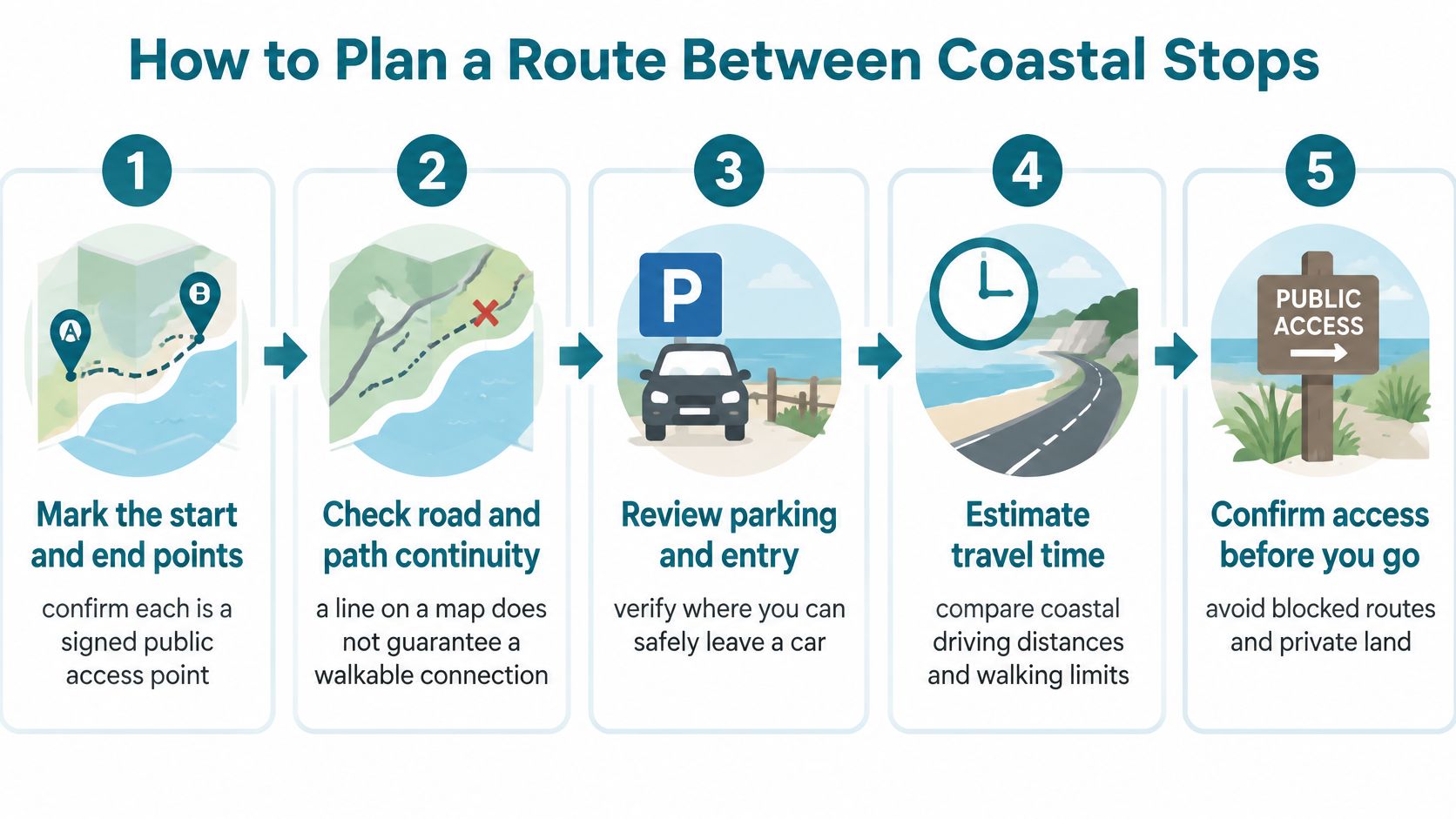
Build the route in order
- Mark the start and end points. Confirm each intended entrance is a signed public access point or a mapped county or state parking area. Save the entrance location separately from the attraction so your driver doesn't arrive at the wrong side of a property.
- Check the legal connection. Trace the proposed shoreline route between those entrances. If the route requires an unexplained shortcut across resort grounds or another private parcel, remove that shortcut until authorization is established.
- Match the surface to the group. Compare the proposed walk with its segment description and hazards. Reject a stretch that requires balance, endurance, or exposure tolerance beyond the least capable participant, even if the destination looks close.
- Verify the geometry against current information. The Hawaiʻi Statewide GIS coastline layer derives from U.S. Geological Survey 1983 Digital Line Graph data, so it supports regional orientation rather than precise modern shoreline surveying. Pair that basemap with current imagery and appropriate elevation, bathymetry, habitat, or protected-area information, while checking access independently.
- Review near-shore activity context. Use NOAA's activity layer to understand surrounding marine uses. Don't convert an activity area into an assumed swimming entrance or treat an absence of mapped activity as evidence of safety.
- Make the day-of decision. Check surf, tide, weather, posted notices, and the route's condition. Name a fallback road-based plan with an authorized destination, rather than assuming you can improvise an inland footpath.
Work through Spencer Beach Park toward Mauʻumae
Consider a three-generation household that wants to leave Spencer Beach Park and continue toward Mauʻumae. The key decision happens during the surface assessment, before anyone starts walking. Ask whether everyone can manage uneven ground and return comfortably if the group turns around.
If the answer is uncertain, choose a short out-and-back within a verified suitable portion, or replace the transfer with a drive to another confirmed public entrance. Don't split the group unless the walkers, driver, pickup point, and communication plan are all clear.
This is also where walking time and driving time need separate estimates. A short road transfer doesn't imply an easy coastal walk, and a nearby beach doesn't guarantee a convenient vehicle pickup.
Use the video as supplementary visual context, not as confirmation of present access or conditions.
Save your route notes and entrance locations before leaving your accommodation. Include the fallback destination in the same saved list so changing plans doesn't require another round of searching from a trailhead.
Travel Logistics Between Kohala Bases
Compare bases using the journeys you'll repeat. Airport arrival matters, but the daily trip from your accommodation to a usable beach entrance may matter more over a longer stay.
Start with Kona International Airport as the arrival reference point for a South Kohala itinerary. Check the route to the exact accommodation entrance, then check any planned stop separately. Don't publish or rely on a single airport-to-Kohala journey time when the destination could mean different parts of the coast.
Organize arrival and daily movement
If you're still comparing air access, use this guide to direct flights to Hawaiʻi alongside current airline schedules. Match the arrival plan to vehicle collection, luggage handling, and the group's energy rather than adding a coastal walk automatically.
For movement between Kawaihae, Spencer Beach Park, and Hāpuna, save each road leg individually. Route to the correct parking entrance, and allow for unloading beach equipment and gathering the household before the next departure.
- Arrival day: Keep the first outing optional until you know when everyone will reach the accommodation.
- South Kohala days: Group nearby beach and cultural stops without assuming pedestrian continuity.
- Northern excursion: Give Pololū Valley its own driving window and check the return journey before adding optional stops.
- Upland visit: Confirm the actual destination and authorized inland approach before routing to a broad field-system label.
- Facilities: Check parking and restrooms for each selected stop rather than assuming the next beach has the same setup.
Test the base against a realistic day
A family staying near Hāpuna could keep its local beach days simple and assign a separate day to North Kohala. That arrangement avoids repeatedly packing everyone into a vehicle for journeys that don't serve the day's main purpose.
For a longer stay, add ordinary errands to the comparison. Ask where you'll get food, whether your accommodation has the facilities you need, and how often you'll drive after an outing.
Record unverified details as “confirm current route” or “facility not yet checked” in your planning sheet. A clear unresolved item is more useful than an invented duration that later becomes everyone's expectation.
Where Inventory Concentrates and What the Numbers Mean
A Kohala Coast map earns its keep before the booking page opens. South Kohala's resort-oriented shoreline is the logical first search when developed beach access leads the plan. North Kohala remains a separate search when rural surroundings, history, and northern valley drives set the pace. Attraction pins can pull a household toward an address; legal entry and maintained segments decide whether that address works after arrival.
Hotel-market history can still help, as long as it stays in its lane. Occupancy, average daily rate, and revenue per available room describe how a lodging market performed during a reporting period. They are context for comparison, not current quotes, not availability for your dates, and not a vacation-home price.
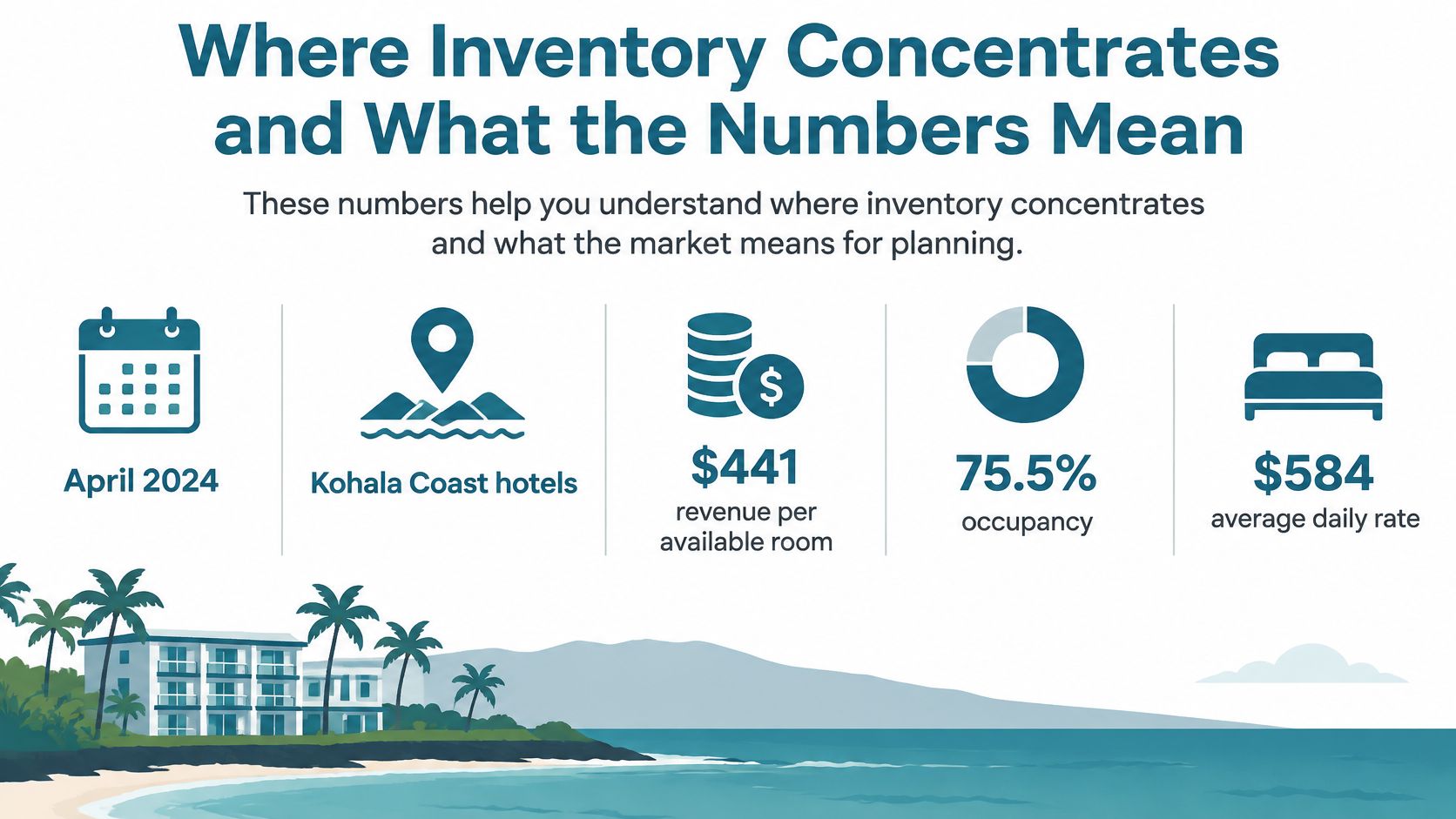
Interpret the measures without overreading them
Read the three measures as instruments on one dashboard. Each answers a different question, and each becomes unreliable when asked to predict a specific stay.
Average daily rate describes room revenue relative to rooms sold. Use it as a historical reference for the market, not as a recommended budget and not as a promise that a suitable room will be offered near that amount.
Occupancy describes the share of available hotel rooms occupied during the reporting period. A regional monthly figure cannot establish availability at a particular property on your dates, especially when your household needs adjacent rooms, specific bed configurations, or coordinated cancellation terms.
Revenue per available room combines the effects of occupancy and room rate. It explains hotel performance, while your final bill depends on dates, room type, fees, and how the household uses the property.
Compare live, like-for-like inventory. Don't turn a regional historical average into a booking quote.
A group organizer should request current availability early enough to compare suitable configurations. That is sensible coordination, and it keeps expectations tied to real rooms rather than to a market summary.
Compare a household stay on equal terms
Say a reunion of eight is considering two vacation homes near Hāpuna versus a resort room block. Keep the dates and map area constant, then compare the actual arrangements rather than headline nightly prices.
Comparison item | Vacation-home questions | Resort-room questions |
|---|---|---|
Sleeping arrangements | Are the beds and bedrooms suitable for the household? | Are the required room types available together? |
Shared time | Is there enough dining and gathering space? | Where can everyone meet without crowding a room? |
Shoreline access | What legal route and maintained segment serve the property? | Which beach entrance serves the booked building? |
Full cost | What charges appear at checkout? | What mandatory property charges apply? |
Flexibility | Can the household change dates or reduce space? | Can individual rooms be changed independently? |
For retirees or remote workers, extend that comparison to laundry, cooking, workspace, and the practicality of repeated errands. A property that suits a brief resort stay may not suit an extended routine.
The right inventory fits both the household and the access plan. A shoreline address alone establishes neither.
Choose Your Base Area and Confirm Access
Choose the area first, verify the accommodation's connections second, and book last. Reversing that order can leave you with an attractive property that requires more driving or harder walking than your household wants.
South Kohala is the stronger starting point when resort beaches and developed coastal access dominate the itinerary. Choose a property with a verified usable connection if walking to the shore matters. Being in the resort corridor isn't enough to establish that connection.
North Kohala is the more appropriate search area when rural surroundings, history, and northern valley excursions shape the trip. Accept that your beach days may need a different driving plan rather than expecting the southern resort experience at every coastal address.
Make the decision around the household
For a snorkeling-centered trip, evaluate the activity's meeting point as well as the accommodation. Kona Snorkel Trips offers a snorkeling stay guide for families that can help you compare base areas against that particular priority.
A family's requirements can also conflict. An older relative may value a predictable entrance and minimal uneven walking, while children may need convenient breaks and a place to regroup. Choose the base that handles the essential needs first, then schedule optional excursions for those who want them.
- Select the area: Prioritize the activities you'll repeat, not the longest list of possible attractions.
- Verify the entrance: Identify the signed public access point and relevant parking near the proposed base.
- Approve each walk: Match its terrain and exit options to the whole group.
- Compare current inventory: Use actual dates, occupancy, bed arrangements, and full booking terms.
- Keep a fallback day: Choose an alternative that doesn't depend on completing an exposed coastal walk.
Book the plan you can actually use
If you're comparing bundled accommodation arrangements, review what all-inclusive Hawaiʻi vacations include before treating a package as a complete logistics solution. Transport, activities, meals, and access arrangements should be checked individually.
Keep a short shared itinerary with the accommodation entrance, planned parking locations, approved walks, and fallback destinations. Give every driver the same locations, and make sure anyone who opts out of a walk knows where the group will reunite.
Your final map of Kohala Coast should show decisions, not merely possibilities. It should make clear where you'll stay, where you'll enter, which routes suit the household, and when you'll use a vehicle.
The map remains a planning tool. It never replaces current conditions, posted signage, or landowner permission where permission is needed.
Approved Experiences Traveler offers Approved Traveler membership access to a consolidated marketplace for comparing hotels and vacation homes, with Reward Credits and a 110% Best Value Guarantee subject to its terms. Visit Approved Experiences Traveler to compare accommodation for your chosen Kohala base, then check the property's entrance, household fit, and booking conditions against your route plan.